
Roads by other Mapmakers
John Ogilby
( Page 1 of 5 )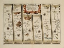
Islip - Bramyard 1675
Bramyard - Aberystwith 1675
Stamford - Newark 1675
Tuxford York 1675
York Durham 1675
London - Dover 1675
Newcastle - Berwick 1675
London - St.Davids Set of 4 Maps 1675


46x33 cm
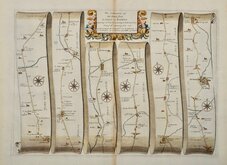
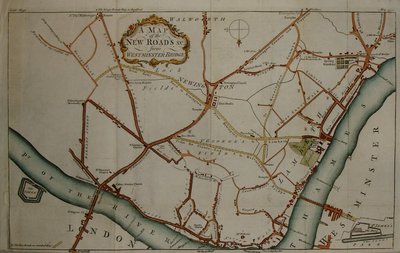
The Road From LONDON to DOVER in cõ: Canty.− Actually Survey'd & Delineated by John Ogilby Esq.r his Maties Cosmographer...
The complete route London to Dover showing London, Southwark, Newington, Deptford, Isle of Dogs, Greenwich Park, Blackheath, Carlton, Shooters Hill, Welling, Crayford, Dartford, Northfleet, Gravesend, Chalk, Gads Hill, Strood, Rochester, Rainham, Lower Halstow, Newington, Key Street, Bobbing, Milton Regis, Sitingbourne, Bapchild, Rodmersham, Lynsted, Norton, Preston, Ospringe, Boughton under Blean, Harbledown, Canterbury, Bridge, Bishopsbourne, Barham, Wootton, Shepherdswell, Lydden, Temple Ewell, River, Buckland, Charlton, Dover.
First state of the plate without plate number issued 1675. Susequently numbered 18.
Very fine early example with generous margins. Strong paper with fleur-de-lis watermark. Fine later hand colour. Includes original typeset text description of the road.
For more information on Ogilby and his work see category heading.
Quick Links

Owen & Bowen
John Cary
×