
Europe
Historical Maps
( Page 1 of 10 )
Saxon Heptarchy Robert Morden 1695

Roman Britain Robert Morden 1695
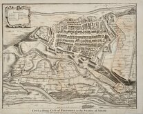
Cuneo Piedmont Savoy 1727
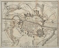
Siege of Tournai 1727
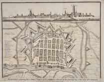
Nieuwpoort Belgium 1727
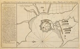
Vijaydurg Fort 1756
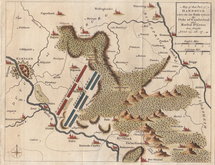
Battle of Hastenbeck 1757
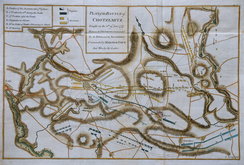
Battle of Kolin 1757


55x42 cm
MAPPING OF THE WORLD
Colour printed lithograph published by Bartholomew & Son. Ltd. in The Times Survey Atlas and Gazetteer of the World. 1922
Map titled CARTOGRAPHY OF THE WORLD 1921 surrounded by historical maps titled: HERODOTUS B.C.450, STRABO A.D.18, MELA A.D.43 PTOLEMY A.D.150, WHEEL MAP XI Century, HEREFORD MAP 1280, THE WORLD c.1800, DE WIT c.1700, ORTELIUS 1570, COSMAS INDICOPLEUSTES VI Century, MOUNTAIN OF COSMAS INDICOPLEUSTES .
Repairs to loss at both top corners outside printed area.
Quick Links


Road Maps

Mediterranean
×