
Wales Maps
Herefordshire Maps
( Page 3 of 3 )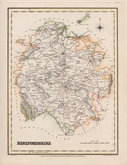
Roger Creighton 1831
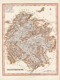
Gray & Son 1833
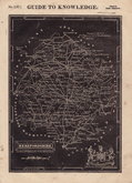
Josua Archer 1833
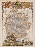
Thomas Moule 1837 [1842]
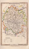
James Pigot 1839
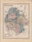
Joshua Archer 1842 [1858]
Geographia 1924


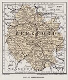
12x18 cm
"OWEN & BOWEN"
A MAP of HEREFORD SHIRE
Map set below a decorative cartouche containing the title and details of the road from Bristol to Chester.
Road map of the first part of the route from Bristol to Chester verso.
Engraved text descriptions below the county map and alongside and below the road map verso.
Engraved by Emanuel Bowen (1693?-1767) and published in the pocket road book Britannia Depicta by Thomas Bowles from 1720 to 1764. The county maps were based on Robert Morden's small series published in The New Description and State of England... from 1701. Text descriptions compiled by John Owen.
Good early impression.
For full description of the road, go to category: Maps > British Isles > RoadMaps > Owen & Bowen.
Quick Links


Worcestershire Maps

Gloucestershire Maps
×