
Eastern Europe & Turkey
Far East & India
( Page 1 of 5 )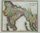
East Indies - Thomson 1820
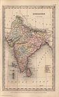
India - Starling 1831
Malaysia - Starling 1831
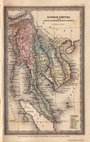
China & Japan - Starling 1831
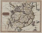
China - Findlay 1835
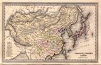
China - Johnston 1843
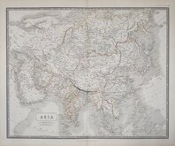
Asia Johnston 1843
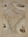
British India - Tallis 1850


61x50 cm
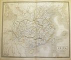
NATIONAL ATLAS 28
CHINA
Engraved by W. & A.K. Johnston.
Edinburgh; John Johnstone and W.& A.K. Johnston; Glasgow; Robert Weir, _ Lunsden & Son.
Steel engraving from The National Atlas of historical, commercial, and political geography published in 1843.
Sir William Johnston (1802-1888), was founder of the engraving, printing and publishing business of W. Johnston which was appointed engravers to King William IV and Queen Victoria. In 1826 his younger brother Alexander Keith Johnston (1804-1871), became a partner and through his influence the firm of W. & A.K. Johnston began cartographic production. It was following publication of the finely engraved and detailed maps for The National Atlas that the firm were appointed Geographers to the Queen.
Inset of River of Canton and Hong Kong.
Original line and wash hand colour.
Quick Links


Asia

Historical Maps
×