
Scotland Maps
England & Wales
( Page 1 of 5 )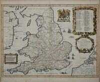
John Ogilby 1676

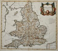
Saxon Heptarchy Robert Morden 1695
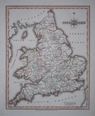
Robert Morden 1695
Herman Moll 1725
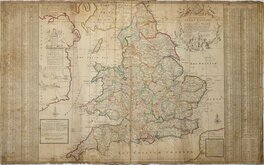
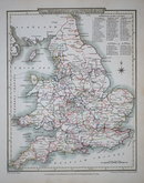
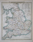
Thomas Kitchin 1763
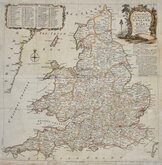
John Cary 1809
John Roper 1809
John Roper 1809


34x34 cm
KITCHIN'S most ACCURATE MAP of the ROADS of ENGLAND and WALES: with the Distances by the Mile-Stones, and other most exact Admensuraations between Town & Town.
Printed for R. and I.Dodsley in Pall-Mall.
Engraved by Thomas Kitchin and published in England Illustrated, Or A Compendium of the Natural History, Geography, Topography and Antiquities Ecclesiastical and Civil, of England and Wales...London R. & J. Dodsley 1763.
The map also appeared, with the imprint of The London Magazine top centre and Kitchin's imprint lower right, in the 1763 edition of The London Magazine published by Benjamin Martin.
Thomas Kitchin (1719-1784), engraver, cartographer and publisher, born in London 4th August 1719, the son of Thomas Kitchin, hat-dyer, and his wife Mary Birr. Apprenticed to Emanuel Bowen (1693-1767) 6th December 1732 to 6th August 1746. He married his master’s daughter, Sarah Bowen, during his apprenticeship, 25th December 1739. Their son, Thomas Bowen Kitchin was born about 1740. An active Baptist, he was deacon of the Barbican Baptist Chapel in 1768 and married Jane Burroughs (1720?-1789), daughter of celebrated baptist preacher Joseph Burroughs (1685-1761). Engraver to the Duke of York from about 1758. Traded as Thomas Kitchin & Son from 1769 and was Hydrographer to the King from 1773. He probably retired sometime around 1776, his premises at The Star, Holborn Hill, which may have been run by his son since their partnership, was taken over by William Hawkes, an apprentice of his son in 1776/1777. He moved to Fishpool Street, St Albans in 1768 and died 23rd June 1784. He was buried in a private vault at St Albans Abbey, his memorial stone on the floor of the Abbey has not survived.
Poor condition, with loss to English Channel and part of France lower right and to right and lower left margins. The map has been pasted on linen at a later date by an amateur hand and has some associated wrinkling. Despite these faults it is still a decorative old map.
Quick Links


Whole of Britain & British Isles

Wales Maps
×