
Whole of Britain & British Isles
England & Wales
( Page 1 of 5 )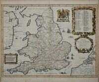
John Ogilby 1676

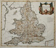
Saxon Heptarchy Robert Morden 1695
Robert Morden 1695
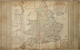
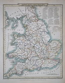
Herman Moll 1725
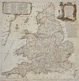
Thomas Kitchin 1763
John Cary 1809
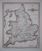
John Roper 1809
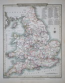
John Roper 1809


98x61 cm
The SOUTH PART of GREAT BRITAIN, called, ENGLAND and WALES.
Containing all ye Cities, Market Towns, Boroughs : And whatever Places have ye Election of Members of Parliament. With ye Rivers, Seaports, Sands, Hills, Moors, Forests &c. All ye Great or Post roads, and Principal Cross-Roads &c. With ye Computed Miles from Town to Town, and all ye Post Towns, as they are present regulated by the Postmasters Gen.l of the General Post House.
According to ye most approved Surveys, and Accurate Observations By Herman Moll Geographer. A.D. 1710.
Printed for H.Moll over against Devereux Court without Temple bar. I. Bowles at ye sign of ye SCREEN over against Stocks Market, and Tho. Bowles Print and Mapseller next to the Chapter House in S.t Pauls Church yard....Sold by Philip Overton Map and Print seller near S.t Dunstans Church Fleet Street.
Herman Moll's large and detailed map of England and Wales flanked by extensive tables of places on the map. Engraved on two plates and printed on two sheets joined, this example is pasted on linen and trimmed to margins. Browning from the verdigris in the green pigments used in the early outline hand colour is evident on the linen verso suggesting this was done shortly after colouring but there are also some tears at the lower border and folds which pre-date the linen backing. Some overall browning and chips and wear to edges.
Little is known about the private life of Herman Moll but his output as an engraver, cartographer, mapseller and globemaker was considerable. Born in Germany about 1654 he is first recorded in London in 1678 producing maps for Moses Pitt's English Atlas. He married Ann Magdalen sometime before 1686 and a son, Gillis Hendrick Moll was baptised at St. Anne, Blackfriars in that year. He worked from addresses in Blackfriars, Charing Cross, and The Strand until his death on 22nd September 1732. His will left all his goods and etates in "Great Brittaine and Germany or elsewhere" to his daughter Henderina Amelia Moll. There was no mention in the will of maps or plates but most came into the hands of John Bowles and Thomas Bowles.
Despite its faults it remains an impressive and attractive example from the fourth state of the map published c.1725.
Shirley Printed Maps of the British Isles Moll 6 State 4. (pp. 89 & 90)
Quick Links


Scotland Maps

Wales Maps
×