
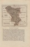
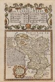
Staffordshire Maps
Derbyshire Maps
( Page 1 of 4 )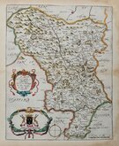
Richard Blome 1673
John Seller 1694 [1784]

Robert Morden 1695
Emanuel Bowen 1720
Thomas Kitchin 1764
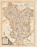
Joseph Ellis 1765 [1773]

John Haywood 1789
Benjamin Baker 1791


40x50 cm
UNCOMMON MAP SURROUNDED WITH HAND COLOURED VIGNETTES
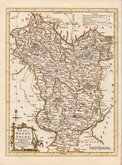
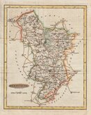
A NEW MAP OF THE COUNTY OF DERBY
COMPILED AND PUBLISHED BY STEPHEN GLOVER.
ENGRAVED ON STEEL BY JOSIAH NEELE, STRAND, LONDON.
Published in The Peak Guide...by Stephen Glover...Derby: Henry Mozley and Sons, 1845.
Engraved by Josiah Neele (1804-1876), son of engraver Samuel John Neele and his wife Mary Chapman. He briefly partnered Ebenezer Stalker (1780-1847), an apprentice to his father, before entering a partnership with his uncle, George Neele (1744-1838) and his brother James Neele (1791-1868). George left the partnership in Sept. 1826 and the brothers continued trading as James and Josiah Neele until Nov. 1829, leaving Josiah to continue the business from The Strand on his own. Elected FRGS in 1831 but resigned the following year. He was declared insolvent in 1836 an his engraving work ceased, becoming a stationer and commission agent. He married Eliza Atwwod from Haverfordwest in 1845 and retired to Wiltshire by 1871 recorded as living with his wife, a sister-in-law, two nieces and two servants. He died at Bradford on Avon 22 March 1876.
This steel engraved map is surrounded by 16 finely engraved vignettes showing clockwise from top left, Matlock Bath, Bakewell Church, Buxton Church, Bolsover Castle, 4 views of Dovedale, Chatsworth, Haddon Hall, DoveHoles, Winnats, Monsal Dale, High Tor, Scarthin Nick, Chee Tor.
Folds as usual with some minor wear at fold intersections re-inforced verso with archival tape. It remains a very good hand coloured example of this finely engraved, decorative and uncommon map.
Quick Links


Leicestershire Maps

Nottinghamshire Maps
×