
Staffordshire Maps
Derbyshire Maps
( Page 1 of 4 )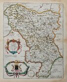
Richard Blome 1673
John Seller 1694 [1784]

Robert Morden 1695
Emanuel Bowen 1720
Thomas Kitchin 1764
Joseph Ellis 1765 [1773]

John Haywood 1789
Benjamin Baker 1791


42x37 cm
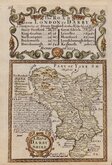
FIRST COUNTY MAPS TO SHOW LONGITUDE FROM LONDON.
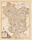
DARBY SHIRE
by Robt Morden
Sold by Abel Swale, Awnsham and John Churchill.
Copper engraving produced by Robert Morden for publication in Edmund Gibson's translation of William Camden's Britannia first published by Abel Swalle and Awnsham & John Churchill in 1695. This is the first series of maps to mark longitude in minutes of time (top border) as well as in degrees (bottom border). For most counties longitude is based on the meridian of St. Paul's, London. Morden is also noted for the inclusion of roads on his maps, his set of playing card maps of 1676 being the first set of county maps to include roads, taken from John Ogilby's Britannia road atlas published a year earlier. This set of county maps also included roads from Ogilby's road atlas and from other sources.
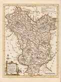
The work was republished in 1722, 1730, 1753 and, finally in 1772. There were a number of minor alterations to most plates during the early editions and they were substantially updated for the 1722 edition mostly with changes to place name spellings. Due to wear caused by the printing process the plates were reworked for the 1753 edition.
Small margins left and right close to plate line at the top of the map and some very minor wrinkling to the paper at the bottom edge but still a very good example of the map of Derbyshire in fine later hand colour from the first edition of 1695.
Quick Links


Leicestershire Maps

Nottinghamshire Maps
×