
Staffordshire Maps
Derbyshire Maps
( Page 1 of 4 )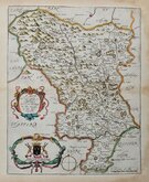
Richard Blome 1673
John Seller 1694 [1784]

Robert Morden 1695
Emanuel Bowen 1720
Thomas Kitchin 1764
Joseph Ellis 1765 [1773]

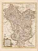
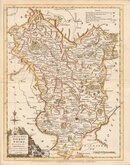
John Haywood 1789
Benjamin Baker 1791


34x47 cm
LARGE PLAIN MAP. NEAT COLOUR.
A MAP OF DERBYSHIRE, ENGRAVED FROM AN ACTUAL SURVEY with Improvements.
Haywood Del. | Sudlow Sc.
London, Engraved for J. Harrison, 115, Newgate Street, as the Act directs, 6th. May, 1789.
This series of county maps were issued at erratic intervals over a four year period bearing dates between 1787 and 1789. The atlas Maps Of The English Counties… was first issued in 1791 by J. Harrison and remained on sale for several years but appears to have not sold well as various reductions in price are recorded.
The border is divided and numbered at 5' intervals with a graticule over the map.
Waterstain to right margin affecting printed area.
Quick Links


Nottinghamshire Maps

Leicestershire Maps
×