
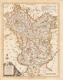
Leicestershire Maps
Derbyshire Maps
( Page 1 of 4 )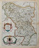
Richard Blome 1673
John Seller 1694 [1784]

Robert Morden 1695
Emanuel Bowen 1720
Thomas Kitchin 1764
Joseph Ellis 1765 [1773]

John Haywood 1789
Benjamin Baker 1791


19x24 cm
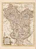
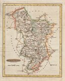
STEEL ENGRAVING. VIGNETTE OF ST MARY'S BRIDGE DERBY.
DERBYSHIRE
Pubd. by Archd. Fullarton & Co. Glasgow.
Steel engraving by Robert Scott first published in Bell's New and Comprehensive Gazetteer in 1833. The text for the gazetteer was largely copied from Lewis' Topographical Dictionary of 1831 and in 1839 Lewis obtained an injunction against Bell for plagiarism and the work was withdrawn. Archibald Fullarton, the publisher ofBell's Gazetteer republished the maps with new text in The Parliamentary Gazetteer from 1840 until 1849. The engraving work was shared between Gray & Son, James Neele and Robert Scott with most maps copied from those by Sidney Hall in an earlier topographical dictionary, John Gorton'sTopographical Dictionary of Great Britain and Ireland published in 1831.
The map bears the compass rose used by Robert Scott. Vignette of St. Mary's Bridge and Chapel, Derby. The extensive railway network added to the map indicates a late edition c. 1848.
Quick Links


Nottinghamshire Maps

Staffordshire Maps
×