
Lancashire Maps
Cheshire Maps
( Page 3 of 3 )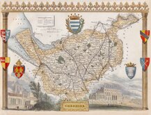
Thomas Moule 1837 [1845]
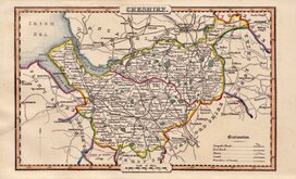
James Pigot 1839
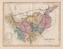
Joshua Archer 1842 [1860]
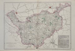
Edward Weller 1863 [1867]
William Hughes 1870
Francis Weller 1891
Cheshire Postcard 1980


26x19 cm
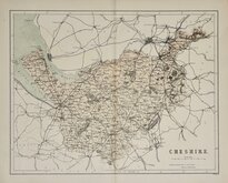
HIGHLY DECORATIVE VICTORIAN MAP.
CHESHIRE.
This series of decorative steel-plate engraved maps are commonly known by the author of the work in which they first appeared; Moule's English Counties Delineated. First issued from May 1830 in a series of parts, the first complete edition was published by George Virtue in 1837. Several editions followed until 1839 and the plates were then used by George Virtue and his son James Sprent Virtue in A Complete and Universal Dictionary of the English Language by the Rev. James Barclay until 1857. The engraving of the plates was shared between James Bingley, William Schmollinger and John Dower. The plates underwent a number of changes, including the unexplained interchanging of engraver's names in the early issues, and were frequently updated to reflect the rapidly developing railway network.
This map of Cheshire was engraved by William Francis Schmollinger (c.1811-1869).
Large vignettes of Chester Cathedral and Eton Hall. With the extensive network of railways shown, this is a late edition c.1845. Small left margin with archival tape added to facilitate framing otherwise a very good example in fine hand colour.
SPECIAL MOUNT OFFER AVAILABLE AT CHECKOUT FOR UK DELIVERY
Quick Links


Road Maps

Staffordshire Maps
×