
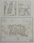
Sea Charts
Channel, Scilly and other small islands.
( Page 1 of 2 )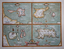
John Speed 1610 [1676]
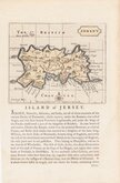
Jersey. John Seller 1694 [1787]
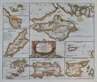
Robert Morden 1695 [1753]
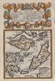
Emanuel Bowen 1720
John Cary 1789 [1805]
Selina Hall. 1830 [1852]
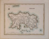
Jersey. Roger Creighton 1831
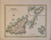
Guernsey. Roger Creighton 1831


25x20 cm
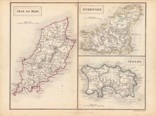
BY A FEMALE ENGRAVER DURING THE REIGN OF WILLIAM IV
ISLE OF MAN.
GUERNSEY.
JERSEY.
ENGRAVED BY S. HALL.
London, Published by Chapman and Hall, 193 Piccadilly.
This series of maps first appeared in Gorton's Topographical Dictionary issued in parts over a three year period from 1830, the complete work not published again after 1833. The maps were then issued in A New British Atlas…, Sidney Hall's British Atlas…, A Travelling County Atlas… and other variations on the title, from 1834 until c.1888. It's popularity due in part to Hall's continuous updating of the plates to include the latest railways. The maps were intaglio printed until c.1858 and then by lithographic transfer.
It has been assumed that all the maps for this series were engraved by Sidney Hall (1788?-1831), but Hall married Selina Price (1780?-1853) in 1821 and his engraving business was continued by his wife after his death in 1831 who signed her maps simply S.Hall. She was obviously a highly skilled engraver, presumably trained by her husband and stylitsticaly there seems to be little difference in their work. Sidney Hall usually signed his maps “Sid.y Hall” so it is reasonable to assume that maps produced around the time of his death signed “S.Hall” are probably by Selina Hall. She is recorded as an engraver on the 1842 Census, living in Bury Street with a servant. She was buried 23 Nov. 1853 at St. George Bloomsbury. In her will, she left her books, maps etc., to her nephew Edward Weller who continued the business
This example, in original outline hand colour, is from the 1852 edition entitled A Travelling County Atlas: with All the Railroads Accurately Laid Down and Coloured published by Chapman and Hall, 193 Piccadilly. (Late 186 Strand.)
Quick Links


British Isles

Europe
×