
Herefordshire Maps
Worcestershire Maps
( Page 1 of 3 )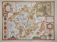
John Speed 1610 [1676]
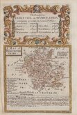
Richard Blome 1673
Robert Morden 1695
Emanuel Bowen 1720
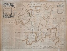
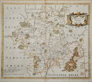
Emanuel Bowen 1756
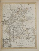
Thomas Kitchin 1764
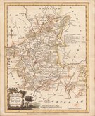
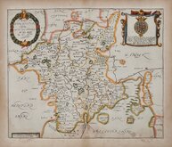
William Fowler 1765
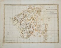
John Haywood 1789

£55
William Fowler Joseph Ellis Ref: 6009.20
Add to
basket
Thanks,Your Product Has Been Added To Basket

19x25 cm
LITTLE KNOWN ENGRAVER.
A Modern MAP of WORCESTER SHIRE Drawn from the latest Surveys; Corrected & Improved by the best Authorities.
W. Fowler sculpt.
Printed for Carington Bowles in S.t Pauls Churchyard & Robt. Sayer in Fleet Street.
Copper engraving by William Fowler first published in The New English Atlas… in 1765, the atlas became a considerable success with many editions, under the title Ellis's English Atlas, from the offices of Robert Sayer and Carington Bowles. Its popularity was due to the cartographical clarity while being of pocket size making it useful for the traveller as well as everyday use in academies and the home. Most of the maps were copied from the maps by Thomas Kitchin in a rival but less popular publication of similar pocket size by Robert Dodsley titled England Illustrated published in 1763.
Most maps in the series were engraved by Joseph Ellis but Worcester and Wiltshire are signed by William Fowler (fl.1765-1766). Born about 1742, the son of William Fowler, gentleman in Shrewsbury, he was apprenticed to Emanuel Bowen 5 Oct 1757. His engraved maps seem limited to the above 2 maps and a 1765 map of Oxfordshire for John Gibson.
The maps remained unchanged in all editions.
Good hand coloured example.
Quick Links


Warwickshire Maps

Staffordshire Maps
×