
Gloucestershire Maps
Wiltshire Maps
( Page 1 of 3 )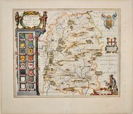
Jan Blaeu 1645
Owen & Bowen 1720
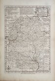
Thomas Kitchin 1751 [c.1786]
Thomas Kitchin 1763
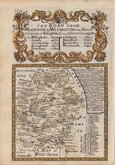
Thomas Bowen 1767 [c.1770]
Benjamin Baker 1795 [c.1807]
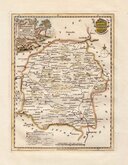
Robert Butters 1803
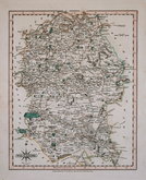
John Cary 1808 [1809]


20x25 cm
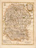
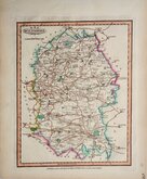
BY A FEMALE ENGRAVER DURING THE REIGN OF WILLIAM IV.
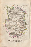
WILTSHIRE.
ENGRAVED BY S.HALL
This series of maps first appeared in Gorton's Topographical Dictionary issued in parts over a three year period from 1830, the complete work not published again after 1833. The maps were then issued in A New British Atlas…, Sidney Hall's British Atlas…, A Travelling County Atlas… and other variations on the title, from 1834 until c.1888. It's popularity due in part to the continuous updating of the plates to include the latest railways. The maps were intaglio printed until c.1858 and then by lithographic transfer.
Original outline hand colour.
Maps with the signature S. Hall are often credited to the engraver Sidney Hall (1788?-1831), but Hall married Selina Price (1780?-1853) in 1821 and his engraving business was continued by his wife after his death signing her maps "S.Hall", while Sidney Hall usually signed his maps “Sidy. Hall”. She was obviously a highly skilled engraver, presumably trained by her husband and stylistically there is little difference in their work giving credence to the possibility that Selina was responsible for some of his output towards the end of his career. Selena Hall is recorded as an engraver on the 1842 Census, living in Bury Street with a servant. She was buried 23 Nov. 1853 at St. George Bloomsbury. In her will, she left her books, maps etc., to her nephew Edward Weller who continued the business.
This example, in original outline hand colour, is from the 1852 edition entitled A Travelling County Atlas: with All the Railroads Accurately Laid Down and Coloured published by Chapman and Hall, 193 Piccadilly. (Late 186 Strand.)
Quick Links


Hampshire Maps

Berkshire Maps
×