
Hampshire Maps
Wiltshire Maps
( Page 1 of 3 )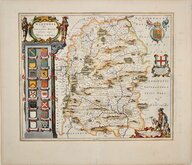
Jan Blaeu 1645
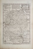
Owen & Bowen 1720
Thomas Kitchin 1751 [c.1786]
Thomas Kitchin 1763
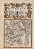
Thomas Bowen 1767 [c.1770]
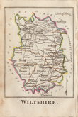
Benjamin Baker 1795 [c.1807]
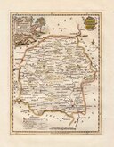
Robert Butters 1803
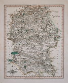
John Cary 1808 [1809]


19x24 cm
EARLY STEEL ENGRAVING. BRIGHT HAND COLOUR.
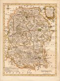
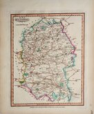
WILTSHIRE.
Pub.d by Arch.d Fullarton & C.o Glasgow.
Steel engraving by Robert Scott first published in Bell's New and Comprehensive Gazetteer in 1833. The text for the gazetteer was largely copied from Lewis' Topographical Dictionary of 1831 and in 1839 Lewis obtained an injunction against Bell for plagiarism and the work was withdrawn. Archibald Fullarton, the publisher of Bell's Gazetteer republished the maps with new text in The Parliamentary Gazetteer from 1840 until 1849. The engraving work was shared between Gray & Son, James Neele and Robert Scott with most maps copied from those by Sidney Hall in an earlier topographical dictionary, John Gorton'sTopographical Dictionary of Great Britain and Ireland published in 1831.
Robert Gray (1771?-1848), Scottish engraver, lithographer and copperplate printer, trading from Glasgow as "Gray & Todd" between 1804 and 1806 and as "Gray & Son" from 1825 to 1848, initially with his son John, and later with his son James who continued the business after Robert Gray's death until at least 1856.
Very good example in neat line and wash hand colour from an edition of The Parliamentary Gazetteer with Fullarton's Glasgow address removed from the imprint.
Quick Links


Gloucestershire Maps

Berkshire Maps
×