
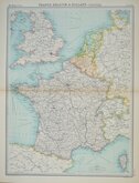
Whole of Europe
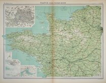
Whole of France
( Page 5 of 5 )

57x44 cm
FRANCE IN DEPARTMENTS
BY KEITH JOHNSTON. F.R.S.E.
KEITH JOHNSTON'S GENERAL ATLAS
Engraved, Printed and Published by W.& A.K.Johnston, Edinburgh & London.
Inset map left: FRANCE IN PROVINCES with their PRINCIPAL SUBDIVISIONS previous to 1789.
Inset Map centre right: ENVIRONS OF PARIS
Inset map lower right: CORSE (Corsica)
Lithographic printed map published in Keith Johnston's General Atlas under the full title:
The Royal Atlas Of Modern Geography Exhibiting, In A Series Of Entirely Original And Authentic Maps, The Present Condition Of Geographical Discovery And Research In The Several Countries, Empires, And States Of The World By The Late Alexander Keith Johnston ... With Additions And Corrections To The Present Date By T.B. Johnston ...W.& A.K. Johnston, Edinburgh and London, MDCCCXCIII.
Overprinted in blue indicating rivers and sea and hand coloured in line and wash indicating political boundaries.
Centerfold split to centre of map repaired archival tape verso. Some browning to centrefold.
Quick Links

Parts Regions & Departments of France

Whole of Britain & British Isles
×