
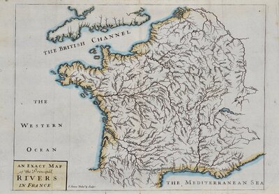
Whole of France
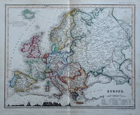
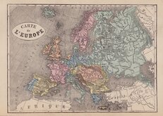
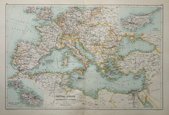
Whole of Europe
( Page 1 of 2 )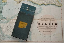
Aaron Arrowsmith 1842
Ethnographic Map 1843
Selina Hall 1843
Central Europe by Hughes 1846
August Petermann 1860
Libraire Historique et Scientific 1877
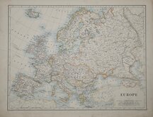
W & A K Johnston 1884
J G Bartholomew 1892


200x168 cm
MAP EXHIBITING THE GREAT POST ROADS, PHYSICAL AND POLITICAL DIVISIONS OF EUROPE FROM ORIGINAL MATERIALS COLLECTED FROM THE DIFFERENT COUNTRIES DELINEATED BY A.ARROWSMITH HYDROGRAPHER TO HIS LATE MAJESTY.
LONDON; PUBLISHED APRIL 10.TH 1840, BY G.F.CRUCHLEY, MAPSELLER & PUBLISHER, 81 FLEET STREET.
ADDITIONS TO 1842
Large four sheet folding map of Europe, each sheet measures 100x84cm. to give an overall map size of 200x168cm. Each map segmented into 12 sections and pasted on linen.
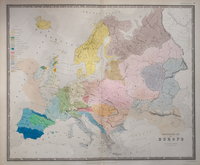
Engraved by Edward Jones and first published Aaron Arrowsmith in 1810. The map extends from Iceland and Portugal in the West to Astrakhan on the Caspian Sea and Berezniki in the Urals in the East, and from Nordkaap (North Cape), Norway in the North, to the islands of Malta, Gozo, and Cyprus in the South.
The engraver, Edward Jones (fl.1799-1818) worked for many mapmakers and publishers including Benjamin Smith, Robert Laurie and James Whittle, Charles Smith, William Faden, John Rowe and James Wyld. He was in partnersip with Benjamin Smith and then together with Joseph Bye. He was imprisoned for debt in the Kings Bench in July 1806.
Aaron Arrowsmith (1750-1823) born at Winston, Durham, he was working as a land surveyor in London by 1777. He married Catherine Palmer in 1780 and they had seven daughters by 1800. He married Sarah Hare in 1801 and had a further five children including two sons, Aaron and Samuel, who would continue the family business. He became Hydrographer to the Prince of Wales about 1810 and then Hydrographer to King George IV. He worked for mapmakers Andrew Dury, William Faden and for John Cary as surveyor for Cary’s Actual Survey of the Post Roads between London and Falmouth. By 1790 he had established his own business and published A Chart of the World on Mercator’s Projection. Throughout the 1790’s and early 1800’s he published many large scale wall maps of several regions of the world, usually linen backed and segmented, and sold individually. He died in Soho on 23rd April 1823.
George Frederick Cruchley (1797-1880), the publisher of this map, was trained by Aaron Arrowsmith.
This example is from a later issue updated to 1842 published by G.F. Cruchley, Three of the maps have a pasted label verso advertising Cruchley's Catalogue of Maps, Atlases &c., Catalogue of Handbooks and Continental Guides, and Cheap Maps by the Late Mr Arrowsmith.
The slipcase is a little worn with a short split and some loss to Cruchley's pasted label.
A fabulous and scarce example of a beautifully engraved map, the largest map of Europe published at the time, in fine condition and in superb original wash hand colour.
Quick Links
Germany
Italy
×