
Middlesex Maps
Surrey Maps
( Page 2 of 5 )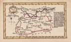
John Gibson 1759
Joseph Ellis 1765 [1773]
Antonio Zatta 1779
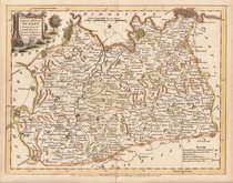
John Haywood 1788
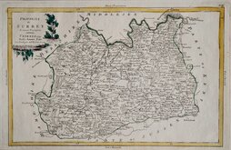
Cadell & Davies 1791
Benjamin Baker 1794 [1806]
Charles Smith 1801
Robert Butters 1803


24x18 cm
FIRST EDITION, ORIGINAL HAND COLOUR
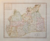
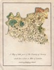
SURREY
Engraved by J. Roper, from a Drawing by G. Cole. | to accompany the Beauties of England and Wales.
London: Published for the Proprietors, by Vernor & Hood Poultry, Jan.y 1.st 1808.
Engraved by John Roper (1771-1810), a London engraver and copperplate printer trading from New Street Square from 1797 until his death in 1810. His widow, Mary Roper, continued the business at the same address until at least 1846. This series of maps, most drawn by G[eorge?] Cole, were intended to accompany The Beauties of England and Wales. The maps were not actually published with this work but first issued in parts as a separate series between 1804 and 1810 and first appearing in atlas form in The British Atlas published by Vernor Hood & Sharpe (& nine other publishers) in 1810. The maps were re-issued in several publications including Dugdale's Curiosities of Great Britain until 1843. Their final appearance was by lithographic transfer in Collins' railway and pedestrian atlas… published by Darton and Co. in 1858.
This example of the map of Surrey is the first copperplate printed state. Red underlining to a number of place names in a later hand but still a good example in original hand colour.
Quick Links


Sussex Maps

Kent Maps
×