
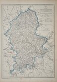
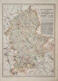
Worcestershire Maps
Staffordshire Maps
( Page 4 of 4 )


10x17 cm
MINIATURE PIGOT. INCLUDES 30 PAGES OF TEXT, DISTANCE TABLE AND VIGNETTE OF LITCHFIELD CATHEDRAL.
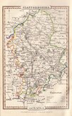
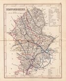
STAFFORDSHIRE
Pigot & Slater Engravers Manch.r
PUBLISHED BY PIGOT & C.o LONDON AND MANCHESTER.
Lithographic transfer produced by James Pigot and Isaac Slater for publication in Pigot & Co.'s pocket atlas, topography and gazetteer of England…London and Manchester J. Pigot & Co. 1839. The engraved plate was not used for direct intaglio printing.
The work was issued twice more in 1841 and 1850 and individual county sections were also issued separately.
James Pigot (1769-1843) was born in Macclesfield, he married Mary Battersby 31st January 1791 at Manchester Cathedral. Trading as "James Pigot & Co." from about 1820 withe London bookseller Charles Elkins and later with his apprentice, Isaac Slater. Elkins died in 1835 and the partnership with Slater continued as "Pigot & Co.", changing to "Pigot & Slater" from 1839 to 1843. He also traded separately as "Pigot & Son from 1828 to 1839 with his son, also James (1798-1857).
James Pigot is well known for his steel engraved county maps and directories published from about 1813. This series of miniature lithograph printed maps were based on his larger steel engraved series published from 1828, but the work did not achieve the success of the earlier publication and the maps are uncommon today.
A good map in original hand colour with lithograph printed engraving of Lichfield Cathedral, distance tables, and 30 pages of typeset text description of the county.
Quick Links


Derbyshire Maps
Shropshire Maps
×