
Leicestershire Maps
Nottinghamshire Maps
( Page 2 of 4 )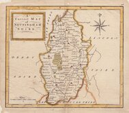
Thomas Hutchinson 1748
John Haywood 1788
Robert Butters 1803
John Cary 1805
John Cary 1808 [1809]
Henry Cooper 1808 [1825]
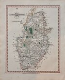
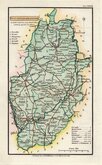
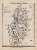
George Cole 1810
George Cole 1810


42x35 cm
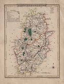
FIRST MAP OF THE COUNTY TO SHOW LONGITUDE FROM LONDON.
NOTTINGHAM SHIRE by Robt. Morden
Sold by Abel Swale Awnsham & John Churchill
Copper engraving produced by Robert Morden for publication in Edmund Gibson's translation of William Camden's Britannia first published by Abel Swalle and Awnsham & John Churchill in 1695. This is the first series of maps to mark longitude in minutes of time (top border) as well as in degrees (bottom border). For most counties longitude is based on the meridian of St. Paul's, London.
The work was republished in 1722, 1730, 1753 and, finally in 1772. There were a number of minor alterations to most plates in the series during the early editions and many were substantially updated for the 1722 edition mostly with changes to place name spellings. Due to wear caused by the printing process the plates were reworked, with re-engraving to the finer cuts which had become indistinct, for the 1753 edition.
Very good impression from the first edition printed on fine paper. Fine later hand colour. Good margins all round..
Quick Links


Derbyshire Maps

Lincolnshire Maps
×