
Derbyshire Maps
Nottinghamshire Maps
( Page 2 of 4 )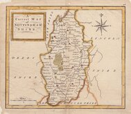
Thomas Hutchinson 1748
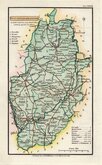
John Haywood 1788
Robert Butters 1803
John Cary 1805
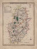
John Cary 1808 [1809]
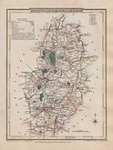
Henry Cooper 1808 [1825]
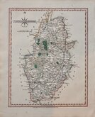
George Cole 1810
George Cole 1810


26x45 cm
LARGE CLEAR MAP
A New accurate & correct Map of NOTTINGHAMSHIRE: Engraved from an actual Survey, with other improvements by E. Sudlow, No.191, Strand.
Haywood Del.t | Sudlow sc.
Engraved for J. Harrison, No.115, Newgate Street, as the Act directs, 15 Aug. 1788.
This series of county maps were issued at erratic intervals over a four year period bearing dates between 1787 and 1789. The atlas Maps Of The English Counties… was first issued in 1791 by J. Harrison and remained on sale for several years with various price reductions recorded suggesting that sales were disappointing.
The border is divided and numbered at 5' intervals with a graticule over the map.
Hand coloured. Some additional creasing at folds.
Quick Links


Leicestershire Maps

Lincolnshire Maps
×