
Cambridgeshire Maps
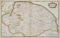
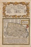
Norfolk Maps
( Page 1 of 3 )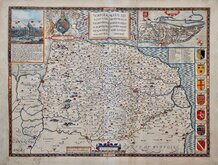
John Speed 1610 [1627]
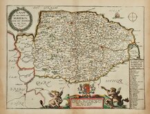
Richard Blome 1673
Robert Morden 1695
Emanuel Bowen 1720
Thomas Read 1744 [1753]
Thomas Kitchin 1750 [c.1786]
Thomas Conder 1784
John Cary 1787 [1793]


22x15 cm
UNCOMMON.
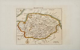
NORFOLK
Sidy.Hall sculpt. 14. Bury Stt. Bloomsby.
Copper engraving by Sidney Hall for Excursions in the County of Norfolk...[by Thomas Kitson Cromwell] London, Longman, Hurst, Orme, and Brown et al. 1818.
Sidney Hall (1788?-1831), began work as an engraver about 1809 with a map of the Austrian Dominions for William Faden in 1809. He was in partnership with Michael Thomson (fl.1809-1815) in 1814. Hall was a pioneer in engraving on steel producing steel engraved maps from from 1821. He married Selina Price in 1821 and died early in 1831 aged forty-two. Selina carried on his engraving business signing her maps "S. Hall" which has caused some confusion in map bibliographies.
A good hand coloured example of an uncommon map appearing in the single publication. Vertical fold as issued but with some additional creasing at the fold. The margins top and bottom are fairly small, 4mm with loss of publishers imprint in the lower margin.
Ref. Frostick Printed Maps of Norfolk [83]
Quick Links


England & Wales

Owen & Bowen
×