
Cambridgeshire Maps
Norfolk Maps
( Page 1 of 3 )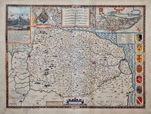
John Speed 1610 [1627]
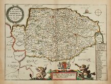
Richard Blome 1673
Robert Morden 1695
Emanuel Bowen 1720
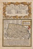
Thomas Read 1744 [1753]
Thomas Kitchin 1750 [c.1786]
Thomas Conder 1784
John Cary 1787 [1793]


12x9 cm
RARE FIRST ISSUE FROM THE RARE "UPSIDE-DOWN" SERIES.
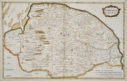
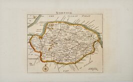
NORFOLK,
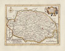
The engraver or engravers of this series of maps are unknown and the maps are known by the first publisher, Robert Butters, a Fleet Street printer, who issued them in An Atlas of England... in 1803. They are also referred to as the "upside-down series" as the England map and many of the county maps are engraved with North to the bottom of the page. In fact, the county maps are variously orientated with North to the top, left, right or bottom. The work was possibly intended for school use and the odd orientation of the maps may have been done to appeal to young minds. This represented Robert Butters' only serious venture into cartography but unlike the huge success of John Cary's publication The Traveller's Companion, on which these maps were based, Butter's publication was limited to this singe issue. John Hatchard acquired the plates later the same year issuing them in a two-volume work The Picture of England 1803, and 1804. The publications were very small and examples are rare.
This map of Norfolk is orientated traditionally with North to the top of the page but the North Point is incorrectly pointing south.
The title is engraved in the bottom margin followed by a comma, which was issued the first edition of An Atlas of England published by Robert Butters in 1803. The two later editions have the title re-engraved in the left margin reading sideways followed by a full stop.
A very good example of a rare map from the first issue in original hand colour.
Ref. Raymond Frostick The Printed Maps of Norfolk [66.1]
Quick Links


Owen & Bowen

England & Wales
×