
England & Wales
Norfolk Maps
( Page 1 of 3 )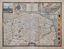
John Speed 1610 [1627]
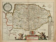
Richard Blome 1673
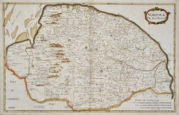
Robert Morden 1695
Emanuel Bowen 1720
Thomas Read 1744 [1753]
Thomas Kitchin 1750 [c.1786]
Thomas Conder 1784
John Cary 1787 [1793]


33x24 cm
ORIGINAL OUTLINE COLOUR SHOWING THE POOR LAW UNIONS.
NORFOLK
Drawn by R.Creighton. | Engraved by J & C. Walker.
DRAWN AND ENGRAVED FOR LEWIS' TOPOGRAPHICAL DICTIONARY.
Copper engraving, by John and Charles Walker from a drawing by Roger Creighton issued in A Topographical dictionary of England… published by Samuel Lewis and Co. from 1831. The work achieved considerable success and was re-issued many times by Lewis until 1849. During this time the maps were amended and updated to include electoral information and the rapidly expanding railway network, with most counties known in at least six different states.
This map is from the 1840 edition with the county divided into the administrative units according to the Poor Law Reform act of 1834 and the addition of the Eastern Counties Railway to Norwich and Great Yarmouth.
Some spotting. Original outline hand colour highlighting the Poor Law Unions.
Ref. Printed Maps of Norfolk Raymond Frostick [105.4]
Quick Links


Cambridgeshire Maps

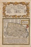
Owen & Bowen
×