
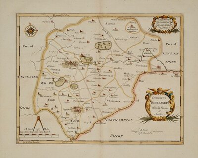
Rutland Maps
Lincolnshire Maps
( Page 3 of 3 )

24x31 cm
FIRST EDITION FINE HAND COLOUR.
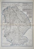
LINCOLNSHIRE
Drawn by R. Creighton | Engraved by J & C Walker.
DRAWN AND ENGRAVED FOR LEWIS' TOPOGRAPHICAL DICTIONARY.
Copper engraving by brothers John Walker (1790?-1873) and Charles Walker (1799?-1872) trading as “J & C Walker” from about 1827. John Walker is known for his work for James Horsburgh and the East India Company as well as his work for the Admiralty and leading publishers of the period. He was founder member of the Royal Geographical Society in 1830. The map was drawn by Roger Creighton and published in A Topographical Dictionary of England…Samuel Lewis and Co. from 1831. The work achieved considerable success and was re-issued many times by Lewis until 1849. During this time the maps were regularly updated to include parliamentary and electoral information and changes to the rapidly expanding railway network.
Good example from the first edition in fine hand colour.
Ref. Carroll Printed Maps of Lincolnshire 93 (i)
Quick Links

Cambridgeshire Maps

Nottinghamshire Maps
×