
Cambridgeshire Maps
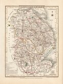
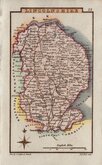
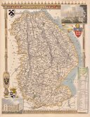
Lincolnshire Maps
( Page 2 of 3 )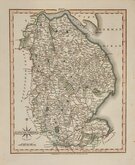
John Cary 1809
George Cole 1810
Sidney Hall 1820

Roger Creighton 1831
Thomas Moule 1831 [1842]
James Pigot 1839
Gray & Son 1840

Joshua Archer 1842 [1858]


18x24 cm
ORIGINAL WASH COLOUR
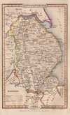
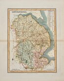
LINCOLNSHIRE
Drawn & Engraved by J. Archer, Pentonville, London.
First published in Curiosities of Great Britain, England and Wales Delineated…by Thomas Dugdale by L.Tallis in 1842. The work was re-issued a number of times until 1860. The maps also appeared in The Universal English Dictionary…by the Rev. James Barclay and finally in Tallis's topographical dictionary of England & Wales in 1860.
Joshua Archer (c.1792-1863), Engraver, cartographer and copperplate printer, was born in Barnstaple in Devon. His first recorded work as an engraver was a map of Scotland for Robert Wilkinson in 1814. He was declared bankrupt in 1835, imprisoned for debt in 1845 but recorded as a map and chart engraver aged 69, on the 1861 census, living in Islington with his wife, Jane, a son, John, also a map and chart engraver, Albert Archer, (map and chart draughtsman) and his wife Elizabeth and three children.
This map of Lincolnshire, with the addition of several railways, is from the 1858 edition of Dugdales England and Wales Delineated.
Good example in original wash hand colour.
Ref. Carroll Printed Maps of Lincolnshire 112 (v)
Quick Links


Nottinghamshire Maps
Rutland Maps
×