
Northamptonshire Maps
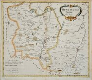
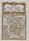
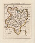
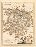
Huntingdonshire Maps
( Page 1 of 5 )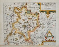
William Kip 1607 [1637]
Michael Drayton 1622
Jan Blaeu 1645
John Seller 1694 [c.1784]
Robert Morden 1695
Owen & Bowen 1720
Thomas Read 1744 [1769]
Thomas Kitchin 1763


42x27 cm
FIRST MAP OF THE COUNTY TO SHOW LONGITUDE IN LOCAL TIME AND DEGREES. FIRST EDITION.
HUNTINGDON SHIRE. By Robt. Morden.
Sold by {Abel Swale Awnsham & Iohn Churchil.
Copper engraving produced by Robert Morden for publication in Edmund Gibson's translation of William Camden's Britannia first published by Abel Swalle and Awnsham & John Churchill in 1695.
This is the first series of maps to mark longitude in minutes of time (top border) as well as in degrees (bottom border). For most counties longitude is based on the meridian of St. Paul's, London.
The work was republished in 1722, 1730, 1753 and, finally in 1772. The plate was updated for the 1722 edition mostly with changes to place name spellings and was reworked for the 1753 edition due to wear on the plate.
This example is from the first edition of 1695. Small top margin and a light diagonal crease through the title cartouche but a good impression in good condition with no tears or repairs in neat later hand colour.
Quick Links


Cambridgeshire Maps

Bedfordshire Maps
×