
Hertfordshire Prints
Hertfordshire Maps
( Page 1 of 11 )
William Kip 1610

John Speed 1614

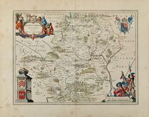
John Speed Original Colour 1616

Jan Jansson 1646
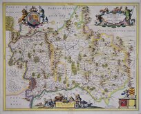
Jan Jansson 1646

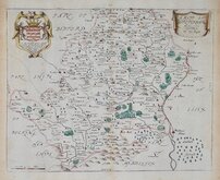
Pieter Keere 1646
Jan Blaeu 1662
Richard Blome 1673


46x33 cm
A | MAP | OF | HERTFORDSHIRE, | ENGRAVED FROM AN ACTUAL SURVEY. | with Improvements.
Haywood del. | Sudlow sc.
London, Engraved for J.Harrison, 115, Newgate Street, as the Act directs, July 4 1788.
Drawn by John Haywood and engraved by Edward Sudlow, this series of county maps were issued as loose sheet maps at erratic intervals over a four year period bearing dates between 1787 and 1789. They were first issued in atlas form in Maps Of The English Counties… in 1791 by John Harrison and remained on sale for several years. It seems that sales were disappointing as various reductions in price are recorded. Despite the claim in the title that the maps were from an actual survey, they were mostly based on the maps of Kitchin and Bowen published in The Large English Atlas or one of the derivatives. The border is divided and numbered at 5' intervals with a graticule over the map.
Good example from the first edition, good margins, neat hand colour.
Hodson Printed Maps of Hertfordshire ref. 50 (i)
Quick Links

Middlesex Maps
Essex Maps
×