
Gloucestershire Maps
Herefordshire Maps
( Page 1 of 3 )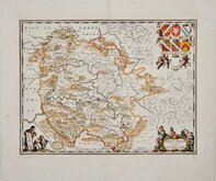
Jan Jansson 1646 [c.1681]
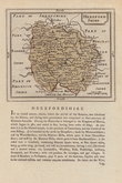
John Seller 1694 [1784]
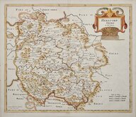
Robert Morden 1695 [1753]
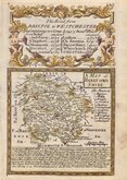
Emanuel Bowen 1720
Joseph Ellis 1765 [1773]
John Haywood 1787
John Cary 1789 [1791]
John Cary 1789 [1805]


20x25 cm
UNCOMMON. NEAT HAND COLOUR.
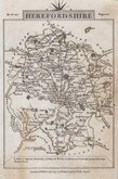
HEREFORDSHIRE.
Neele Sculpt. Strand.
Published by J. Robins & Co. Albion Press, London January 1. 1818.
Drawn and engraved by Samuel John Neele, this series were based on John Cary's 'quarto' maps of 1793. The early publication of this series is complex with loose issues and parts issues for many counties from about 1812. The first main publication containing the complete set of county maps was The New British Traveller; or, modern panorama of England and Wales...By James Dugdale... published about 1818 by J & J Cundee. The map appeared in only three further issues under different titles in 1819 and 1820.
This example of the map of Herefordshire, with the imprint of J Robins, is dated 1818 and was published by J Robins & Co.from 1819 to 1820. Small margins as usual with this series. Some nicks to right edge including a short repaired tear extending 10mm into the printed map near Whitborn (Whitbourne).
Neat hand colour.
Quick Links


Worcestershire Maps

Wales Maps
×