
Gloucestershire Maps
Herefordshire Maps
( Page 3 of 3 )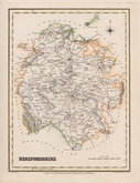
Roger Creighton 1831
Gray & Son 1833
Josua Archer 1833
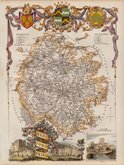
Thomas Moule 1837 [1842]
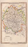
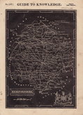
James Pigot 1839
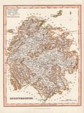
Joshua Archer 1842 [1858]
Geographia 1924


43x36 cm
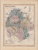
FIRST TO SHOW LONGITUDE FROM LONDON AND LOCAL TIME
HEREFORD SHIRE By Robt. Morden.
Sold by Abel Swale Awnsham & Iohn Churchil.
Copper engraving produced by Robert Morden for publication in Edmund Gibson's translation of William Camden's Britannia first published by Abel Swalle and Awnsham & John Churchill in 1695. This is the first series of maps to mark longitude in minutes of time (top border) as well as in degrees (bottom border). For most counties longitude is based on the meridian of St. Paul's, London.
The work was republished in 1722, 1730, 1753 and, finally in 1772. The plate was updated for the 1722 edition mostly with changes to place name spellings and was reworked for the 1753 edition due to wear on the plate.
Very good example in later hand colour of the map of Herefordshire from the 1753 edition.
Quick Links


Wales Maps

Worcestershire Maps
×