
English Counties
Folding Maps
( Page 8 of 17 )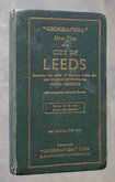
Leeds Geographia 1937
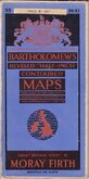
Bartholomew Moray Firth 1940
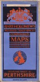
Bartholomew Perthshire 1941
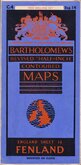
Bartholomew Fenland 1942
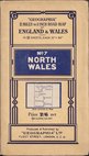
Geographia North Wales 1943
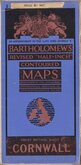
Bartholomew Cornwall 1944

Bartholomew South Yorks and Humber 1944
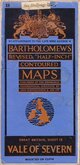
Bartholomew Vale of Severn 1947


104x114 cm
PLAN OF LEEDS
Produced & Published by "GEOGRAPHIA" L.TD 55 FLEET STREET, LONDON E.C.4.
COPYRIGHT "GEOGRAPHIA" L.TD 55 FLEET STREET, LONDON, E.C.4.
Based upon the Ordnance Survey Maps with the sanction of the Controller of H.M. Staionery Office, with additions obtained from Local Authorities.
Cover title:
"GEOGRAPHIA" New Plan of the CITY OF LEEDS Including the whole of the area within the City showing the POSTAL DISTRICTS with complete Index to Streets [Shows all the new Roads and Estates] ON CLOTH 7/6 NET Published by "GEOGRAPHIA" LTD. 55 FLEET STREET. LONDON, E.C.4
Green cloth boards 13x21cm. Index affixed inside front cover and map inside back cover. Linen backed lithograph printed map over printed in red, yellow, green and blue. Un-segmented, folded into 54 sections.
Scale 4" to a Mile, the map divided into ½ mile squares covering an area of just over 100 sq. miles, extending to Eccup in the North, Crossgates in the east, Middleton in the South, Stanningley in the West.
Some wear at folds. Edge wear to covers. Ownership inscription to front of index and tape repairs to index hinge. Generally in very good condition with no tears or repairs to map. No date but Geographia code gives January 1937.
Quick Links


Regional Maps of England & Wales

Ordnance Survey Maps
×