
Ordnance Survey Maps
Folding Maps
( Page 7 of 17 )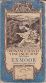
O.S. Exmoor 1934

O.S. Plymouth 1934
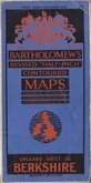
Bartholomew Berkshire 1934
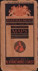
Bartholomew North Yorkshire Coast 1935
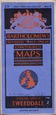
Bartholomew Tweeddale 1937
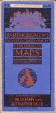
Bartholomew Buchan and Strathbogie 1937
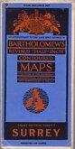
Bartholomew Surrey 1937
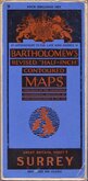
Bartholomew Surrey 1937


84x63 cm
ORDNANCE SURVEY "ONE INCH" MAP
ORDNANCE SURVEY OF GREAT BRITAIN
EXMOOR
Fifth Edition, ENGLAND & WALES. SHEET 119
Published by the Director General at the
ORDNANCE SURVEY OFFICE, SOUTHAMPTON, 1934.
Revision of 1930-1. 1,000/34.
Linen backed. Ellis Martin cover.
Condition: Fair. Covers worn. Some wear and staining at folds. Ink manuscript owner's name and address top margin.
Quick Links


English Counties

Regional Maps of England & Wales
×