
Wales Maps
England & Wales
( Page 2 of 5 )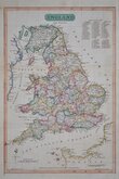
Nathaniel Coltman 1809

Bowles England & Wales 1811
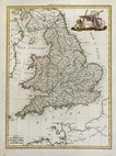
Pierre Lapie 1815
Thomson 1820
John Cary 1822
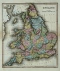
Aaron Arrowsmith 1828
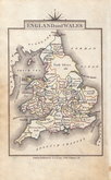
Roger Creighton 1831 [1842]
Roger Creighton 1831 [1845]


25x37 cm
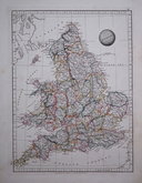
ENGLAND | AND WALES.
[ Published 1st.January,1808,by Robt.Laurie and Jas.Whittle, No.53 Fleet Street, London.]
Published in Laurie and Whittles New Traveller’s Companion…in England, Wales and Scotland…London, Laurie & Whittle, 1806.
The work was a road book with maps prepared by Nathaniel Coltman, the map is unsigned by engraver or draughtsman but it is assumed that he also prepared this general map of England and Wales.
Robert Laurie (1755-1836) was apprenticed to Robert Sayer and after working independently for a few years, returned to work with Sayer. James Whittle (1757-1818) also worked for Sayer and with Robert Laurie became his junior partner as “Sayer & Co.” in 1790. In 1794 they took over the business and stock trading as “Laurie & Whittle”. Robert Laurie retired in 1812 and his son, Richard Holmes Laurie became Whittle’s new partner with the firm now trading as “Whittle and Laurie”.
Repair to short split at left centrefold just affecting map border but a good clean example in original hand colour.
Quick Links


Scotland Maps

Whole of Britain & British Isles
×