
Northumberland Maps
Durham Maps
( Page 3 of 4 )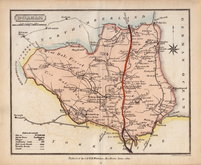
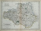
Samuel John Neele 1820 [c.1821]
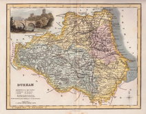
George & John Cary 1822
Roger Creighton 1831
Selina Hall 1833
Sidney Hall 1833 [1852]
Robert Scott 1833 [c.1848]
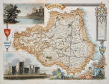
Thomas Moule 1837 [c.1845]
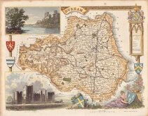
Thomas Moule 1837 [c.1845]


52x40 cm
CARY STOCKDALE
A MAP of DURHAM from the best AUTHORITIES.
Published by John Stockdale Piccadilly 26th. March 1805.
Engraved by J. Cary.
Copper engraving by John Cary. The maps were first issued in parts by T. Payne & Son, and G.G.J. & J. Robinson for Richard Gough's translation of William Camden's Britannia, the completed work being published in 1789. Following the death of Payne, the Robinson family sold the plates and publication rights to John Stockdale. Richard Gough was reportedly annoyed with the new arrangements and refused to work on the new edition and Stockdale completed the editorial work himself, expanding the work to four folio volumes and publishing them in 1806. Stockdale also used the plates in his New British Atlas from 1805 to 1809.
This example of the county of Durham is from the Stockdale edition of 1805. Good margins A good clean example in fine hand colour.
Quick Links

Durham Prints

Yorkshire Maps
×