
Town Plans
Cambridgeshire Maps
( Page 1 of 4 )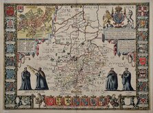
John Speed 1611
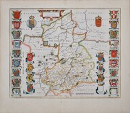
Jan Blaeu 1645
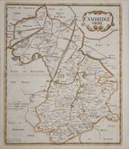
Robert Morden 1696 [1753]
Emanuel Bowen 1720
Thomas Read 1743 [1769]

Thomas Kitchin 1750 [1786]
George Bickham 1752
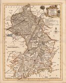
Joseph Ellis 1765


20x25 cm
NEAT ENGRAVING FINE HAND COLOUR.
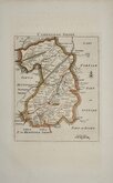
CAMBRIDGE S.
Neele Sculpt. Strand.
Drawn and engraved by Samuel John Neele, this series were based on John Cary's 'quarto' maps of 1793. The early publication is complex, with loose maps and parts issues for many counties sold by James Cundee from about 1812. The first publication containing the complete set of county maps was The New British Traveller; or, modern panorama of England and Wales...By James Dugdale... published about 1819 by J & J Cundee. The maps appeared in three further issues with the imprint of J. Robins & Co. under various titles.
Samuel John Neele (1758-1824) was a prolific engraver working from Russell Court from 1781 and 352 Strand from 1785-1824. He traded with his younger brother George Neele as “S.& G. Neele” 1826-1824 and with his son James Neele as “Neele & Son” 1816-1824.
Small margins top and left with some browning. Some spotting in blank area of Suffolk.
Quick Links


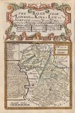
Road Maps
Cambridgeshire Prints
×