
Cambridgeshire Prints
Cambridgeshire Maps
( Page 1 of 4 )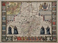
John Speed 1611
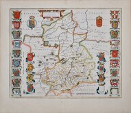
Jan Blaeu 1645
Robert Morden 1696 [1753]
Emanuel Bowen 1720
Thomas Read 1743 [1769]

Thomas Kitchin 1750 [1786]
George Bickham 1752
Joseph Ellis 1765


9x13 cm
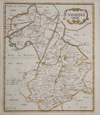
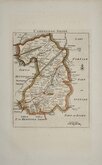
RARE “UPSIDE-DOWN” SERIES
CAMBRIDGESHIRE.
The engraver or engravers of this series of maps are unknown. Robert Butters, a Fleet Street printer, issued them in An Atlas of England... in 1803. They are known as the "upside-down series" as many of the maps are engraved with North to the bottom of the page. In fact, the county maps are variously orientated with North to the top, left, right or bottom of the page. The work was possibly intended for school use and the odd orientation of the maps may have been done to appeal to young minds. This represented Robert Butters' only serious venture into cartography but unlike the huge success of John Cary's publication The Traveller's Companion, on which these maps were based, Butter's publication was limited to this single issue. John Hatchard acquired the plates later the same year issuing them in a two-volume work, The Picture of England 1803 and 1804. The publications were small and surviving examples are rare.
This example of the map of Cambridgeshire is, unusually, orientated traditionally with North to the top of the page. Original outline colour. First issue of 1803. Overall even toning.
Owner’s handwritten dip-pen inscription verso reads;
Edward Maginnis his Book
No.5 Chymister alley Bedford
Berry Covent Gardin
London oct 23rd.1853
By Thomas Burke London
James Mahoney
Quick Links

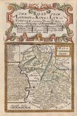
Road Maps

Town Plans
×