
Cambridgeshire Prints
Cambridgeshire Maps
( Page 1 of 4 )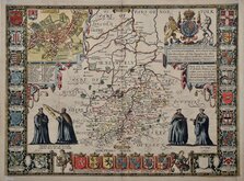
John Speed 1611
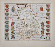
Jan Blaeu 1645
Robert Morden 1696 [1753]
Emanuel Bowen 1720
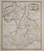
Thomas Read 1743 [1769]

Thomas Kitchin 1750 [1786]
George Bickham 1752
Joseph Ellis 1765


18x23 cm
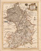
UNCOMMON. NEATLY ENGRAVED MAP IN NEAT HAND COLOUR.
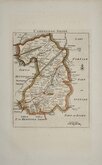
CAMBRIDGESHIRE
Engrav'd by B. Baker Islington
Copper engraving by Benjamin Baker from The Universal Magazine of Knowledge and Pleasure..., the maps appearing between 1791-1797, published by W. Bent. This was the second series of county maps issued in the magazine, the first series by Emanuel Bowen and Thomas Kitchin was published between 1747-1766 by John Hinton. Baker's maps were based on the 'quarto' maps of John Cary published from 1787. This series is the first known work by Benjamin Baker who is also noted for his engraving work on the earliest maps for the Ordnance Survey until his retirement c.1824.
The maps also appeared unchanged in Maps of the Several Counties and Shires in England… published by Darton and Harvey in 1804. Laurie & Whittle published them with a number of revisions to the plate, including a compass rose and Laurie & Whittle's imprint, in Laurie & Whittle's New and Improved English Atlas… 1807 & 1816.
Good hand coloured example of the map of Cambridgeshire from the magazine issue. Folds as issued and one light diagonal fold top right corner.
Uncommon.
Quick Links

Road Maps

Town Plans
×