
Map Books
Atlases & Road Books
( Page 1 of 4 )
Gardner English Traveller
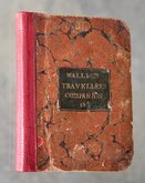
Wallis's Travellers Companion
Ogilby Traveller's Guide 1712
Cox Magna Britannia Hertfordshire 1720
Magna Britannia Hertfordshire by Thomas Cox 1720
Senex Norden Speculum Middlesex & Hertfordshire 1723
Senex Norden Speculum Middlesex & Hertfordshire 1723
Mostyn Armstrong Great Post-Roads 1783


Request Condition Report
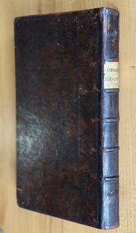
A New Pocket Atlas and Geography of England and Wales...By John Luffman Geog.r. London. Printed for Lackington, Allen & C.o Temple of the Muses Finsbury Square. 1806.
18mo. (10x16cm) Half red morroco, pasted label to front board. Title. 2pp preface dated March 1803. 2pp advertisements for other works published by Luffman. Fold-out map of England and Wales. Half title: England. 42 engraved circular county maps above text description printed one side only. Half title: Wales. 12 engraved circular county maps above text description printed one side only. Index.
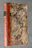
Original binding, chips to spine with loss top and bottom, original pasted label to front board; LUFFMAN'S ATLAS & GEOGRAPHY OF ENGLAND AND WALES. Price 7/6 Plain, or 10/6 in Colors. Owners manuscript signature to front endpaper; Miss Lord Aug.st 12.th 1814. Small ink stamped symbol to bottom of front endpaper. Folding map with closed tears to hinge and lower centrefold extending into the map to the lower horizontal fold. 54 uncoloured county maps, but lacks Merioneth, a duplicate Montgomery plate is printed in its place in error. Yorkshire West Riding printed close to the paper edge with loss of plate number.
A very good example of an uncommon and unusual little atlas in full original binding with scarce pages of advertisements.
Quick Links
General & Collectable
Antiquarian
×