
Ordnance Survey Maps
Folding Maps
( Page 5 of 18 )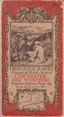
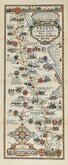
O.S. Chichester Worthing 1920
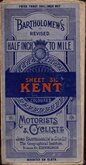
Bartholomew Kent 1922
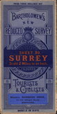
Bartholomew Surrey 1924
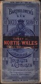
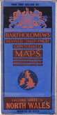
Bartholomew North Wales 1924
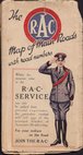
R.A.C. England 1925
Bartholomew North Wales 1929
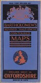
Bartholomew Oxfordshire 1929
Alfred Taylor 1930


77x54 cm
ORDNANCE SURVEY Contoured Road Map of CHICHESTER AND WORTHING
ORDNANCE SURVEY OF ENGLAND AND WALES
CHICHESTER & WORTHING
POPULAR EDITION ONE-INCH MAP
SHEET 133 (Sussex.)
Engraved at the ORDNANCE SURVEY OFFICE Southampton.
...Printed at the Ordnance Survey Office Southampton. 1920.
Linen backed. Ellis Martin cover.
Condition: Fair-poor. Covers worn. Wear at folds, splits starting. Sellotape stains at 3 corners, paper layered at 1 corner where sellotape removed.
Quick Links


Regional Maps
English Counties
×