
Fifty inch and 1:1250
Twenty five inch and 1:2500
( Page 1 of 17 )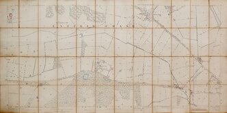
Enfield Chase 1885
Burley Yorkshire 1:2500 1893
Bayfordbury Herts 1898
Gilston Herts 1898
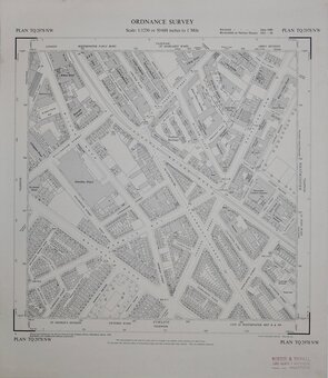
Totteridge Whetstone Herts 1898
Wyddial & Layston Land Exchange 1902
Pontefract Yorks 1907
Monken Hadley Herts 1914


£20
Ordnance Survey Ordnance Survey Ref: XLV.11.12
Add to
basket
Thanks,Your Product Has Been Added To Basket
Request
Condition Report
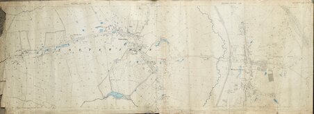
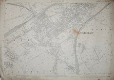
Two sheets joined:
HERTFORDSHIRE SHEET XLV. 11 MIDDLESEX SHEET VI. 11
SECOND EDITION 1898
Zincographed and Published by the Director General of the Ordnance Survey Office, Southampton, 1898.
Scale: 1/2500 - 25.344 Inches to a Mile.
HERTFORDSHIRE SHEET XLV. 12 MIDDLESEX SHEET VI. 12
SECOND EDITION 1898
Zincographed and Published by the Director General of the Ordnance Survey Office, Southampton, 1898.
Scale: 1/2500 - 25.344 Inches to a Mile.
Both sheets with oval blind stamp in top margin: BOARD OF AGRICULTURE ORDNANCE SURVEY COLOURED. Water features hand coloured in blue. Unfolded. Worn and marked with chips and tears to paper edges and some loss at left margin including a tear at centre extending to "Oak Lodge".
Showing Oak Lodge, St. Edwards School, Totteridge Common, Totteridge Park, The Grange, Totteridge, Copped Hall, St Andrews Church, Totteridge Lane, Great North Road, Whetstone, Friern Barnet Lane, Oakleigh Park.
Quick Links

Other Large Scales

Six inch and 1:10000
×