
Bedfordshire Maps
Huntingdonshire Maps
( Page 2 of 5 )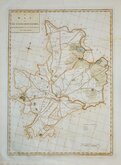
John Haywood 1788
John Cary 1789 [1805]
Robert Butters 1803
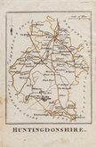
Cole & Roper 1806
Cole & Roper 1806
Cole & Roper 1806
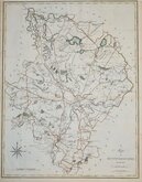
Henry Cooper 1808
John Cary 1808 [1809]


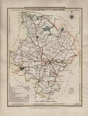
20x25 cm
ORIGINAL OUTLINE HAND COLOUR.
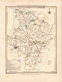
HUNTINGDON SHIRE.
ENGRAVED BY SIDY. HALL
London, Published by Chapman & Hall, 193 Piccadilly.
This series of maps first appeared in Gorton's Topographical Dictionary ssued in parts over a three year period from 1830, the complete work not published again after 1833. The maps were then issued in A New British Atlas…, Sidney Hall's British Atlas…, A Travelling County Atlas… and other variations on the title, from 1834 until c.1888. It's popularity due in part to Hall's continuous updating of the plates to include the latest railways. The maps were intaglio printed until c.1858 and then by lithographic transfer.
This intaglio printed example, with Chapman & Hall’s Piccadilly address, was published from 1852 to 1857. Original outline hand colour.
Quick Links


Cambridgeshire Maps

Northamptonshire Maps
×