
Cambridgeshire Prints
Cambridgeshire Maps
( Page 3 of 4 )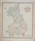
John Cary 1809
George Cole 1810
Samuel Neele 1819
Sidney Hall 1820
John Cary 1822
Aristide Perrot 1824
Roger Creighton 1831
Sidney Hall 1831


48x54 cm
CARY'S FINE FOLIO SERIES. FIRST ISSUE. NO CENTREFOLD.
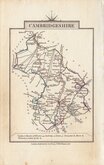
A NEW MAP OF CAMBRIDGESHIRE, DIVIDED INTO HUNDREDS EXHIBITING Its Roads, Rivers, Parks &c. By JOHN CARY Engraver. 1806.
London Printed for J Cary Engraver & Map seller No.181 Strand June 1.1808.
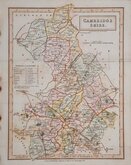
John Cary (c.1754-1835) began sales of his series of folio county maps in parts issues from 1801, the complete series being published in Cary's New English Atlas in 1809. The atlas was deservedly successful running to over ten editions before Cary's death. The plates passed to G F Cruchley about 1846 and to Gall and Inglis in 1877 and were issued by both publishers under various titles by lithographic transfer with continuous amendments, particularly to the rapidly changing railway network until their final appearance in Cruchley's railway and telegraphic county atlas of England and Wales published by Gall and Inglis about 1887.
In addition to this extended publication in atlas form, the maps were also issued continuously from 1801 to 1890 as folding maps sold separately. The plates were probably disposed of as scrap metal during the first world war.
This fine example of the county of Cambridgeshire, in full original hand colour and dated 1806, is from the first edition of 1809 or, more probably, from an earlier parts issue, later top-edge bound (the only edge which does not appear to be the original paper edge), without centrefold, into a large oblong folio atlas, with a small pasted number to top right corner of each map.
Quick Links

Town Plans

Road Maps
×