
Central London
Ward Plans and Parts of London
( Page 1 of 8 )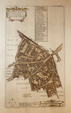
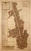
Aldgate Ward 1720
Aldgate Ward 1720
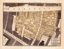
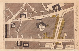
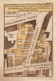
Cornhill Fire 1748
Westminster 1753
Aldersgate Ward. 1755
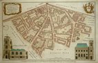
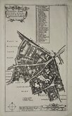
Aldgate Ward 1756
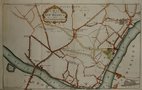
Bishopsgate Fire 1765
Bishopsgate Fire 1765


36x24 cm
ALDGATE WARD | with its DIVISIONS into | Precincts & Parishes | according to a | NEW SURVEY.This Plan is most humbly inscribed to ROBERT SCOTT Esqr. Alderman of ALDGATE WARD.
Copper engraving by Benjamin Cole. Despite the claim in the title that the plan is According to a new Survey, it is actually closely copied from Richard Blome's engraved plan. Richard Blome's plans were based on the survey of London by John Ogilby and William Morgan (the surveyor was William Leybourn assisted by John Holwell and Gregory King) and produced for Reverend John Strypes illustrated version of John Stow's Survey of London published in 1720. Cole's plans, were produced for the second edition of William Maitland's History of London published in 1756 (the first edition, published 1739 did not include maps). Cole's maps are more decorative and finely engraved than those of Blome, replacing the list of places and columns of references with engraved views of important landmarks (mostly taken from West and Tom's Perspective Views of the Ancient Churches published in 1736 ), and with rococo title cartouches and coats of arms.
Maitland's History was republished in 1760, 1772 and 1775 but Cole's plans were not revised for any of these issues and continued to represent London as surveyed by Leybourn a hundred years earlier.
Includes vignettes of the churches St. James's Duke Place and St. Catherine Coleman.
Quick Links


Environs of London

Middlesex Maps
×