
Norfolk Maps
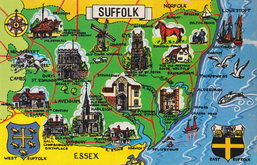
Suffolk Maps
( Page 4 of 4 )

23x18 cm
FROM DUGDALE'S CURIOSITIES
SUFFOLK.
Drawn and engraved by J. Archer Pentonville London.
Drawn and engraved by Joshua Archer ((1792?-1863) for publication in Curiosities of Great Britain, England and Wales Delineated…by Thomas Dugdale.
The work was first published by L. Tallis in 1842 and was republished a number of times until 1860. The maps also appeared in The Universal English Dictionary…by the Rev. James Barclay and finally in Tallis's topographical dictionary of England & Wales in 1860.
This example, includes the addition of the eastern Union and Norfolk Railways published c.1848.
Original hand colour. Centrefold split repaired.
Quick Links

Cambridgeshire Maps

Essex Maps
×