
Mediterranean
Sea Charts
( Page 1 of 3 )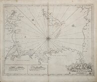
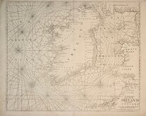
Greenville Collins Irish Sea 1688 [c.1693]
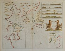
Orkney 1693
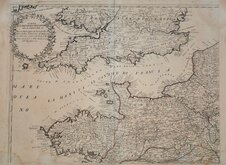
English Channel by Petrini 1715
Bay of Toulon 1739
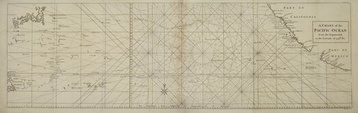
Pacific Ocean by Anson 1748
English Channel 1753
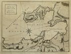
Burnham Flamborough Head Berwick 1755
Mount & Page 1756


101x65 cm
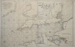
A NEW and CORRECT CHART of the CHANNEL between ENGLAND & FRANCE: with considerable Improvements not extant in any Draughts hitherto Publish'd; Shewing the Sands, Shoals, depths, of Water, and Anchorage, with ye flowing of the Tydes, and setting of the Current; as observed by the Learned D.r Halley.
Sold by Page & Mount on Tower Hill London.
Copper engraving on two sheets joined first published in Greenvile Collins' Great Britain's Coasting Pilot 1693.
Greenvile Collins (1643-1694) was an officer in the Royal Navy and became a prominent hydrographer, most noted work being the first survey of the coasts of Britain by an Englishman, his Coasting Pilot. Appointed by King Charles II in 1682, he began his survey under the supervision of Trinity House, taking seven years on the task and culminating in a folio work containing tables, coastal views and forty-nine sea charts covering England, Wales and Scotland. His intentions to include Ireland were not realised. Richard Mount (1654-1722) obtained the rights to sell the work and in partnership with Thomas Page (fl.1700-1733) went on to publish twenty-one further editions.
Insets of Plymouth Sound and the Isle of Wight.
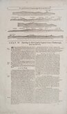
Additional creasing to the lower half of the centrefold and join between the two sheets and some tape repairs verso to damage at this join and the intersection with the lower horizontal fold (see 2nd image). Still a good example of this important and detailed sea chart.
Quick Links

Map Books
Maritime
×