
Map Books
Sea Charts
( Page 1 of 3 )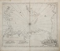
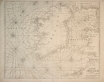
Greenville Collins Irish Sea 1688 [c.1693]
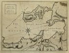
Orkney 1693
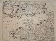
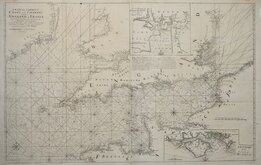
English Channel by Petrini 1715
Bay of Toulon 1739
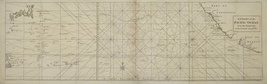
Pacific Ocean by Anson 1748
English Channel 1753
Burnham Flamborough Head Berwick 1755
Mount & Page 1756

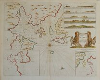
£30 Kerguelen Islands, Desolation Islands
Ref: 2016g
Add to
basket
Thanks,Your Product Has Been Added To Basket

35x24 cm
THIRD VOYAGE OF CAPTAIN JAMES COOK
Four charts on the plate titled:
TERRE DE KERGUELEN, Appellée par M. Cook,
ISLE DE LA DÉSOLATION.
Par M. Bonne, Ingénieur - Hydrographe de la Marine.
ILES découvertes par Mr. Marion du Fresne en 1772: appellées par M. Cook en 1776, ISLES DU PRINCE EDOUARD.
PLAN DU PORT PALLISER dans la Terre DE KERGUELEN.
PLAN DU HAVRE DE NÖEL dans la Terre DE KERGUELEN.
Décl. 27° 45' E.1777.
Imprints outside border:
Cook, 3e. Voyage. 140
Bonne Fil. del. | André sculp.
Drawn and published by French cartographer Rigobert Bonne (1727-1794) in his Atlas Encyclopedique...Paris 1788.
Bonne's maps mark a departure from the decorative maps of the 17th and 18th century towards a more accurate and detailed topography.
This chart shows the Kerguelen Islands in the southern Indian Ocean officially discovered by French navigator Yves-Joseph de Kerguelen-Tremarec in February 1772 and visited by Captain Cook in December 1776 (the map incorrectly giving 1772).
Quick Links

Mediterranean
Maritime
×