
Asia
Scandinavia
( Page 4 of 4 )
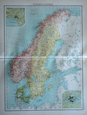
£10 Sweden & Norway by Bartholomew
Ref: 876.16
Add to
basket
Thanks,Your Product Has Been Added To Basket

31x42 cm
Colour printed map By John Bartholomew published in his Citizen's Atlas 1898.
Inset maps of the environs of Stockholm and Christiana (Oslo).
Quick Links


Whole of Europe

Eastern Europe & Turkey
×