
Leicestershire Maps
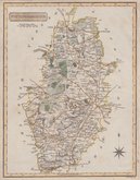
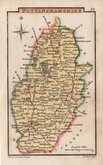
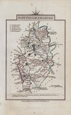
Nottinghamshire Maps
( Page 3 of 4 )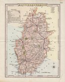
George Cole 1810 [1838]
Samuel John Neele 1818
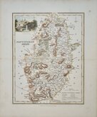
Sidney Hall 1820
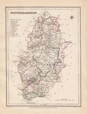
John Cary 1822
Roger Creighton 1831 [1845]
Robert Scott 1833
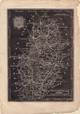
Joshua Archer 1833
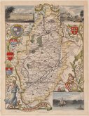
Thomas Moule 1837 [1844]


17x23 cm
WOOD ENGRAVED MAP FROM "THE GUIDE TO KNOWLEDGE"
NOTTINGHAM SHIRE.
London, W. Edwards, 12 Ave Maria Lane.
J. Archer sc. 100 Drummond Str. Euston Sq.
Woodblock engraved map by Joshua Archer. The woodblock was inked with a roller without working the ink into the engraved cuts thereby printing with a white line on a black ground. Published in parts by W. Edwards in The Guide to Knowledge edited by W Pinnock from 1833 The printing method was not popular for topographic maps and was not used again for English county maps. The woodblocks were later published by Thomas Johnson printed more conventionally by lithographic transfer in his rare publication Johnson's Atlas of England in 1847 & 1863.
Fraying at paper edges, one closed tear on right edge just reaching the printed border. Good example of the map of Nottinghamshire from The Guide to Knowledge.
SPECIAL OFFER MOUNT OPTION AVAILABLE AT CHECKOUT FOR UK POSTAGE
Quick Links


Lincolnshire Maps

Derbyshire Maps
×