
Derbyshire Maps
Nottinghamshire Maps
( Page 4 of 4 )

19x26 cm
HIGHLY DECORATIVE STEEL ENGRAVED MAP
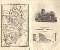
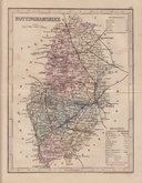
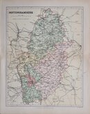
NOTTINGHAMSHIRE
This series of maps were produced for publication in Moule's English Counties, the engraving work shared between Schmollinger, John Dower and James Bingley. The work was first issued in parts from 1830 and first appearing complete in atlas form in 1836, published by George Virtue. Virtue later used the plates for publication in Barclay's Universal English Dictionary from 1842 until 1852. The plates were continuously amended to reflect the changes to the country affected by the rapidly growing railway network with most county plates known in over eight or more different 'states'.
The maps are commonly known as 'Moule's' as they first appeared in the works above. Thomas Moule (1784-1851) was a writer on heraldry and antiquities, a bookseller, and, finally, Inspector of blind letters for the Post Office and Chamber-Keeper of the Lord Chamberlain's Department.
Includes vignettes of Worksop Manor, Nottingham castle and Newstead Abbey.
Light overall browning to the edge of an old mount but with generous margins the edge is well away from the printed area. In later hand colour from the 1844 edition of Barclay's Dictionary.
Quick Links


Lincolnshire Maps

Leicestershire Maps
×