
Derbyshire Maps
Nottinghamshire Maps
( Page 4 of 4 )

11x28 cm
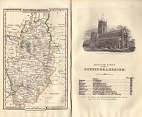
MINIATURE MAP ALSO KNOWN AS "CAPPER" OR "WHITAKER" MAPS
Plate XXVII
NOTTINGHAMSHIRE
Published by G & W.B.Whittaker, 13. Ave Maria Lane. 1824.
Copper engraving by Henry Cooper first published in A Topographical Dictionary...by Benjamin Pitts Capper Esq. by Richard Philips in 1808.
This example, with the signature erased, amended publisher imprint and changes to the statistical information, was published in a work of similar title by George B. Whitaker in 1825 & 1826, by Sir Richard Philips in 1829 & 1834 and finally by Whitaker & Co. in 1839.
Quick Links


Lincolnshire Maps

Leicestershire Maps
×